
Home › Forums › BigTrees Talk › Evacuation Advisory for Arnold
- This topic has 11 replies, 8 voices, and was last updated 10 years, 10 months ago by
Tony.
-
AuthorPosts
-
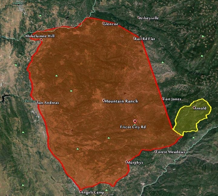
September 12, 2015 at 9:20 am #3643
Tony
ParticipantFire map.
September 12, 2015 at 7:36 am #3635bigtreestechman
KeymasterThere was an update made at 7:15 this morning. http://cdfdata.fire.ca.gov/incidents/incidents_details_info?incident_id=1221
Copied from the update:
Last Updated: September 12, 2015 7:15 am
Date/Time Started: September 9, 2015 2:26 pm
Administrative Unit: CAL FIRE Amador – El Dorado Unit
County: Amador & Calaveras Counties
Location: Butte Mountain Road, east of Jackson
Acres Burned – Containment: 64,728 acres – 10% contained
Structures Threatened: 6,400
Structures Destroyed: 15 structures
Evacuations:Mandatory Evacuation Orders:
(Amador County) Canyon View, Fig Tree Lane, and Ponderosa Way; the Town of Pine Grove to include all areas South of Hwy 88 from West Clinton Road, East to Ranch Drive. Inclusive of the Communities of Ranch House Estates, Pine Acres, Jackson Pines, Pine Drove Ranchettes and Lake Tabeau
(Calaveras County) (Calaveras County) Town of Mokelumne Hill, East of Hwy 49 from the Amador/Calaveras County line South to Goldstrike Road. South on Goldstrike Road to the Community of San Andreas. Rural areas East of San Andreas to Mountain Ranch Road. Mountain Ranch Road to Calaveritas Road to Fourth Crossing. Fourth Crossing to Hwy 49. East side of Hwy 49 South to North side of Hwy 4 (Angels Camp). North side of Hwy 4 East to Town of Arnold. All of SR 26 from Mokelumne Hill North to the Amador/Calaveras County line. To include the communities of Glencoe, Westpoint, and Wilseyville.
Evacuations Advisories:
(Amador County) Hwy 88 from Ranch Road East to Tiger Creek Road (Red Corral and Buckhorn Areas).
(Calaveras County) City of Angels Camp, Hwy 49 South to Hwy 4 South at the city limits of Angels Camp. Town of Arnold, Northwest of Hwy 4 includes sub-divisions of Lakemont, Mill Woods and Meadowmont. Hwy 4 North to Sheep Ranch Road/Blue Lake Springs sub-division, Big Trees State Park, Town of Dorrington, Town of Murphys and Forest Meadows. Town of San Andreas. Poole Station Road, Carroll Kennedy Road, Cement Plant Road, Demearest Mine Road, Oak Valley Road, Gelding Road, Stallion Road, Deer Creek Road, Copello Road.
Evacuation Centers:
(Amador) Jackson Rancheria Hotel, San Andreas Town Hall, Calaveras County Fairgrounds.
Cooperating Agencies: Jackson City, Sutter Creek, Amador Fire Protection District, Diamond Springs, USFS, CHP, Calaveras County Sheriff, BLM, PG&E, Calaveras PUD, OES, CDCR, Sutter Creek Fire Department, Sacramento Metro Fire, Sacramento City Fire, Folsom Fire, El Dorado County Fire, Cosumnes Fire
Total Fire Personnel: 3,299
Total Fire Engines: 383
Total Fire crews: 67
Total Airtankers: 8
Total Helicopters: 17
Total Dozers: 62
Total Water Tenders: 46
Long/Lat: -120.70418, 38.32974
Conditions:Road Closures:
(Amador County) Clinton Road at Butte Mountain Road (Both Ends) Butte Mountain Road Cutoff at Clinton Road. Amador Lane at Clinton Road, Electra at SR 49, Ponderosa Road at Tabeaud, Access to Lake Tabeaud is closed; Hwy 88 at W. Clinton Road, Hwy 88 at Irish Town Road, Hwy 88 at Tabeaud Road, Hwy 88 at Aqueduct Circle, Highway 88 at Mount Zion, SR 26 South of Hwy 88.
(Calaveras County) SR 26 from Mokelumne Hill to Ridge Road; Ridge Road closed to Railroad Flat Road; Railroad Flat Road closed to Mountain Ranch Road; Mountain Ranch Road closed to Hwy 49; Michel Road is closed.
Fire behavior remained extreme throughout the day with rapid, uncontrolled fire growth to the south and east. Unfavorable weather coupled with fuel moistures at critical levels have resulted in explosive fire conditions. Mandatory evacuations continue to expand as the fire continues to grow. Residents are urged to stay vigilant due to current and expected fire conditions.
Amador-El Dorado CAL FIRE is being assisted by the Sacramento Regional Type III Incident Management Team. A CAL FIRE incident management team has been ordered.
Phone Numbers (530) 647-5218 (Fire Information Line)
Phone Numbers (209) 754-5527 (Fire Information Line)September 12, 2015 at 6:35 am #3631Kuma
ParticipantCal-fire has not updated anything since last night.
Any news from locals in the Arnold area?September 11, 2015 at 10:08 pm #3630tortuga
Participanthttp://cdfdata.fire.ca.gov/incidents/incidents_details_info?incident_id=1221
Evacuation now advised for dorrington, mandatory for all west of Arnold.
September 11, 2015 at 7:38 pm #3628ParticipantTwitter feed has latest info..
Update at 7 pm: Cal Fire report the acreage burned in the Butte Fire has grown to 64,728 acres while the containment has dropped to 5%.
https://twitter.com/search?f=tweets&vertical=news&q=%23ButteFire
September 11, 2015 at 6:36 pm #3626ParticipantRecent Map
Attachments:
September 11, 2015 at 6:34 pm #3625ParticipantSeptember 11, 2015 at 2:34 pm #3624mtndad
ParticipantMANDATORY EVACUATION FOR SAN ANDREAS
Instructions:
LEAVE THE AREA IMMEDIATELYAddress/Location
Calaveras County Sheriff’s Office
891 Mountain Ranch Rd
San Andreas, CA 95249September 11, 2015 at 1:53 pm #3622dpalme
ParticipantJust got an email from Sandi at Sierra Sentry:
“*****Evacuation MANDATORY anything east of hwy 49 to dogtown RD
Anything east of gardner
Anything north of murphys grade
All the way up hwy 4 past AVERY to flying acres (just above Avery)Instructions:
EVACUATE IMMEDIATELY. THIS IS MANDATORY.Stay safe up there, folks. Our thoughts are with anyone in the evac zone.
September 11, 2015 at 1:14 pm #3619dhumph
ParticipantCHP SAN ANDREAS: Closed Roads-Mountain Ranch Road, Sheep Ranch Road, entire town of Mountain Ranch, SR-26 Moke Hill to Ridge Rd., Ridge Rd.
September 11, 2015 at 1:11 pm #3618ParticipantCCSO: Mandatory evacuation East of HWY 49 up HWY4 to Avery and North to Mokelumne Hill and West Point.
-
AuthorPosts
- You must be logged in to reply to this topic.